Cycling & Cycle Routes
Local cyclists, will need no introduction to the Vale of Belvoir (pronounced beaver).
The vale is a hidden gem, which is part of its charm, as it is largely passed by in the rush for the more recognised ‘honeypot’ areas of the country.
Make up your own routes around the vale – or check out the links at the bottom of this page.
The escarpment of the Belvoir Edge and the Nottinghamshire Wolds, border the vale to the south. This provides a wonderful, often wooded backdrop – if you want hills – we’ve got ’em!
If the thought of hills is enough to keep you under the duvet – fear not! The bulk of the vale is level – and for those who like their cycling dead flat – I introduce you to the Grantham Canal towpath!
33 miles of sheer delight, with perhaps the two extreme ends not being of interest if you’re out for a day’s cycling in the countryside.
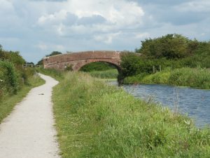
Longore Bridge – rural isolation
Of this 33 miles of towpath – around 22 miles have a crushed stone surface – the remainder being grass. The grass section is (largely) between Harby and Woolsthorpe by Belvoir, and was left in grass, due to these areas being designated Sites of Special Scientific Interest (SSSI).
Check out Sustrans National Cycle Network Route 15. This is particularly useful where it runs parallel with the canal near Woolsthorpe – sign posted off the towpath between Locks 17 and 18. This alleviates using the often muddy section of towpath between Lock 15 and 16. There is extensive restoration work in progress along this section (currently the towpath is fully open here 2021. It maybe 2 years before we begin the restoration of Lock 13).
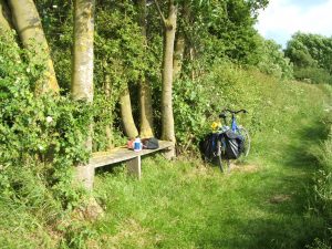
A wayside seat near Muston, with views to Belvoir Castle
The grass sections are usually rideable – perhaps better avoided in very wet weather. Some, in their 4th flush of youth, and no longer racing fit, have found these long stretches of grass a little tiring – please consider this if you’re doing an end to end 😉 A timely note here about hedge cutting. Hedges are predominately Hawthorn and Blackthorn – as cyclists, it’s the last syllable of these two words which will be of interest – thorns mean punctures! Hedges do have to be trimmed. This needs to be done out of the birds nesting season through the autumn and winter. Contractors working for the Canal and River Trust do this work, usually doing a great job in blowing clear the thorns from surfaced towpaths – stay on the surfaced portion! Always be aware of a few stray thorns which get scratched back on by dogs and birds! Clearing grass sections of thorns is not realistically possible. Cycling on these sections during and, for sometime after hedge cutting, invariably increases the risk of punctures – try to ride where others have gone before 😉 Sorry to dwell on this – we’ve had letters 🙁
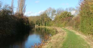
Approaching Lock 13, under a wide blue sky
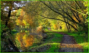
Sheer delight – autumn on the summit level, emerging from Harlaxton cutting
The ‘Grantham Canal Guide’ is an excellent companion to cycling along the towpath – it indicates the type of surface you’ll encounter – along with a wealth of information about the canal and surrounding area – cafes, pubs and restaurants too! Also see the link at the bottom of the page for places where refreshment can be found.
To order your guidebook, click on ‘Guide book’ on the blue menu bar at the top of the page.
I firmly believe lying the OS map out on the floor at home to plan your route is best. The choices of cycling routes are almost endless, most of the lanes are light in traffic. Many of the green lanes and tracks are passable, and are useful when planning your route.
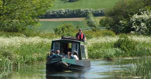
Perhaps you’d like to return and enjoy the canal from a different perspective? Cruises of 2, 3 & 4 hrs can be chartered exclusively for your group – see homepage for details.
If sheer rural isolation appeals, as does the complete absence of motor traffic, and route planning is not your thing – spend the day cycling along the towpath, you won’t be disappointed.
A most enjoyable day’s cycling in the vale awaits!
Notes about road crossings and chicane type barriers at access points:
Two road crossing require particular care:
- A52 Lings Bar, near Gamston, Nottingham. The canal and towpath have been severed here by this very busy road – it is not safe to cross by the more direct (and seemingly obvious) route across this dual carriageway, which also involves scaling the crash barrier on the central reservation. There is a light controlled crossing approx 400mtrs away.
- Bottesford Bridge (Bridge 55), needs care. This bridge was rebuilt some years ago – without providing the towpath under. It’s a little awkward squeezing a bike through the opening to gain access to the road, i.e. panniers may have to be removed. Sight lines aren’t great here for crossing the road. Fortunately, traffic is fairly light.
- Chicane type barriers are installed at many of the access points. These are to help prevent motorcycles from using the towpath. These barriers will not be a problem for most users. Even bicycles with trailers can usually negotiate them without unhitching. Tandems may have to be lifted over the barrier. If no rear mudguard it fitted – the usual trick is to rear the bike up and wheel it around the barrier on its rear wheel. This is often easier with solo bikes too! These barriers will gradually be replaced with ‘K’ type ones (which are actually more the shape of a capital letter ‘A’ – but this will be over a period of some years. In some instances the barriers maybe removed completely.
- There is an issue at Bridge 37, Clawson Lane. This bridge has been lowered in the past, leaving a height above the towpath of approx. 3 feet. To continue along the towpath here has traditionally been through private property. During the pandemic, this access has been denied. Please respect the land owners right to do this. An alternative route will need to be found, avoiding this bridge. The Canal and River Trust are in communication with the landowner. Let’s hope a solution can be found.
…don’t forget your puncture repair outfit/spare tube…
A useful site with information about the Vale of Belvoir, including tearooms & cafes: Visit Belvoir
Some routes around the area: Bikemap
Cafe Allez Routes, ranging from 19miles to a challenging 60miles: Cafe Allez Routes
Please be considerate to other towpath users – slow right down when passing people walking. Please also take care when cycling under bridges, every year we hear of cyclists falling in – it does happen!