Trent Link
Grantham Canal: The Trent Link
1. Preamble
Commercially abandoned in the 1920s, the formal Closure Act of the Grantham Canal was passed in 1936, and in 1968 the canal was placed into a ‘remaindered’ state. This involved maintenance of the water level to support agricultural water supply needs and required general maintenance of the line. These requirements meant that the Grantham fared better than some canals where their line was abandoned and in some cases totally obliterated.
In the 1950s all but 23 of the original 69 bridges over the canal were flattened, many hump-backed canal bridges replaced by concrete pipe culverts with flattened decks. However, the biggest disaster was the loss of the connection into the River Trent, thus access to the whole of the English canal and river network was denied.
The present Lady Bay road bridge was originally the rail crossing for the Midland Railway line from Melton Mowbray to Nottingham Midland Station. When the line was abandoned in 1968, plans were made to convert the river crossing to road use, so relieving pressure on Trent Bridge. This project took some years to deliver, the road bridge opening on September 14th 1980.
Meanwhile, in the late 1960s a proposal was mooted to use the canal through West Bridgford/Gamston as a linear rubbish tip. The response of the Grantham Canal Society was to adopt a policy of full restoration as the best option to save and preserve it. Wise move – the linear rubbish tip idea withered away.
In 1971 Nottinghamshire County Council stated that they would oppose the Grantham Canal Society (GCS) if they wanted to restore the canal along its original route through West Bridgford, alongside Radcliffe Road, as former bridges and road crossings had had services/utilities embedded in them. With the loss of the connection to the Trent this opposition put a major nail in the coffin marked “full authentic restoration”.
The search for alternatives then began in earnest. The Polser Brook route (to be explained in detail later in this text) was explored and adopted by GCS. In the same year Nottinghamshire County Council announced plans to build a new road (Lings Bar), enhance the A52 route and alleviate traffic in West Bridgford. They told GCS they would protect the Polser Brook route if GCS do not oppose the blocking of the Grantham Canal by the new carriageway, to which GCS agreed.
It is worth noting that in the mid 1990s the Grantham Navigation Association reviewed the “full authentic restoration” option and calculated that restoring the original line and link to the Trent would cost in the region of £12 to £15 million (approx. £30m in contemporary terms). Those figures did not include economic and social disruption costs.
The factors and events above effectively buried the “full authentic restoration” option, much as that is regretted by the canal restoration connoisseurs among us. As one commentator has observed:
“Of the many instances of urban disruption and desecration thoughtlessly inflicted on local communities by town and country planners in the 1950s and 1960s, none can be so insensitive as the deliberate permanent closure of the Grantham Canal line from Trent Lock with roads and building works. This single act has left the current generation with an unnecessary £30m bill for a reconnection to link the canal again to the National River Canal Network.”
If anyone wonders about the validity of the concern about the Trent Link it is worth considering it in the context of the whole canal. The old British Waterways was not overly enthusiastic about restoration projects as a whole but by November 2003 it became known that the Grantham Canal would appear in the next tranche of BW priorities.
It was reported that British Waterways, predominant owners of the 33 miles, regarded the Grantham Canal as about the best value for money per mile of the outstanding restorations to be undertaken in the country. It was, and still is, seen as a political, economic and environmental imperative to raise awareness; to embarrass people into taking the rural agenda seriously.
For over 40 years the “strategy” had been to grab every restoration opportunity that arose – and with some success. Contemporary thinking has seen concentration on the Grantham end of the line, since pound for pound there are better economic possibilities of turning the derelict canal into navigable waterway at that end. With that in mind The Grantham Canal Partnership (GCP) has developed a Restoration Plan, which takes a step-by-step approach to regenerating the waterway by gradually restoring a section at a time, whilst continuing to investigate every opportunity to initiate the preparation for the fundamental Trent Link.
2. Trent Link – Strategic Keystone of the Restoration
It is difficult to overstate the strategic importance of the Trent Link. As already noted, the amputation of the canal at the river has left an isolated 33-mile ribbon of water whose inaccessibility is a significant deprivation of the national waterways network. Unsurprisingly, attention has turned to the Link on a number of occasions in the last 50 years but good intentions and some imagination have yet to be translated into effective action.
This isolation has fed the agenda of some individuals, mostly in government (local and national agencies) and the old British Waterways who had argued that inaccessibility justified inaction elsewhere on the canal. Yet among those same groups there have been notable individuals whose actions have effectively contradicted that establishment indifference. Especially, the unknown individual in the Department of the Environment who told the Grantham Navigation Association of the availability of £400,000 in early 1993, the fast acting officers in Nottinghamshire County Council who made the funding application, and Ian White, Regional Director of British Waterways in Leeds. Ian White took on and delivered the project that resulted in nearly three miles of the canal from Hickling eastwards being restored, together with Hicking Basin, and the replacement of three low level concrete rafts with state of the art swing bridges.
Hickling, Cotgrave, the eastern reaches to the A1 and other projects were all achieved outwith the context of a comprehensive restoration strategy. This void was used by some opponents as further justification for inaction and indifference, and Trent Link initiatives suffered as a consequence. It is to the credit of Richard Parry, Chief Executive of Canal and River Trust, that in early 2016 a group was established to develop a comprehensive restoration strategy for the Grantham Canal. The Trent Link will obviously feature strongly in this process.
In the same way that the reopening of the Northern Reaches of the Lancaster Canal gained new impetus from the opening of the Ribble Link becoming a reality, so the prospect of the Trent Link will bring the rest of the canal into renewed focus. Paradoxically, events on the Grantham are the reverse of the Lancaster – without a link most of the action has been at the far end of the Grantham, much to the credit of Lincolnshire County Council and South Kesteven District Council. That said, strategically, no aspect of the restoration is more important than the Trent Link.
3. Trent Link Initiatives
In the period 1973 to date a number of proposals have been made to address the issue of the Trent Link –
1. The Ogden Report (written in 1973 by P.H.Ogden, B.Sc., F.I.C.E., F.I.W.E.) was commissioned by the Grantham Canal Restoration Society. This gave costings for the Trent Link via the Polser Brook route and restoration to navigation of the canal up to its truncation at the A1 embankment just before Grantham.
2. The 1974 Feasibility Study for the Polser Brook connection conducted by D. R. Hill of Loughborough University of Technology (Department of Civil Engineering) assisted by D.V.Jude and M. D. Willetts.
3. In the 1974-published ‘The Grantham Canal Today’ there is reference by Chris Cove-Smith MAIE to the Polser Route
For many years, from the late 1970s to early 1990s both Nottinghamshire County Council and Rushcliffe Borough Council accepted and passively supported the principle of the Polser Brook route, but a legal hitch occurred over its protected status in the 1990s. Both Councils continued to support the proposed Polser connection but GCS were asked, along with the Grantham Canal Partnership, to look at route variations in conjunction with British Waterways (BW).
Studies were to be made of different routes to re-connect to the Trent, including:
1. The original route as far as the overspill on the Adbolton side of Gamston Bridge then across the fields to the Trent
2. Converting the old mineral line from Cotgrave to the Trent into a canal with a ‘Falkirk Wheel’ style lift to raise and lower boats to and from the Trent
3. The Polser Brook route
4. The 1996 Trent Partnership Bid to the Millennium Commission
A group consisting of British Waterways, Volunteer Organisations, and Local Authorities, submitted a grant application to The Millennium Fund, which included the Polser Brook as the new connection to the Grantham Canal.
The project involved a marina development within the Cotgrave Country Park. Reclamation of the former Cotgrave colliery to a country park was used as match funding within the bid. The Country Park design allowed for the construction of a marina.
Sadly, despite a well-prepared and skilfully argued case, the adjudicating committee did not view the proposition with favour.
5. Original Route to Just West of Gamston Bridge
This option pursued the original route as far as the overspill weir on the Adbolton side of Gamston Bridge then across the fields to the Trent. Costs would be incurred dealing with the Lings Bar bridge and the flat deck at Gamston Bridge. Furthermore the route across the fields to the Trent runs through known (but not fully investigated) archaeological sites.
Although not dead current thinking views this option as a secondary contender.
6. 2005: Railway to Waterway – Big Lottery Fund Living Landmarks Initiative
A very imaginative and well-researched project in 2006, incorporating the former railway line to Cotgrave Colliery, two disused mineral rail bridges to carry an aqueduct for the canal and a mini Falkirk Wheel to solve the river to canal height differential was proposed.
This bid, under the title of “Railway to Waterway”, sought to utilise the abandoned line that ran between Radcliffe on Trent and Cotgrave, to terminate at a marina. Any future restoration between the River Trent and Cotgrave will need to include a destination with some mooring capacity. After Cotgrave lies the dry section which would prevent cruising for some time yet.
Nottinghamshire County Council, as a key partner:
1. Supported development of a marina within the Cotgrave Country Park and use of the value of the land as match funding within the bid.
2. Confirmed that there were no strategic planning issues which would conflict with the development as proposed
3. Stated that there were no issues from a highway or public transport perspective which use of the railway track for a canal link would conflict with.
Network Rail confirmed their “in principle” willingness to sell the rail track and structures making up the Cotgrave Colliery Branch. If construction of the canal proved technically feasible then Network Rail land would secure all the land necessary for a link apart from 300 metres adjoining the River Trent and approximately 500 metres belonging to Nottingham County Council at the Cotgrave end.
7. The Polser Brook Route
7.1 Overview
Over a period of nearly 50 years this option keeps re-surfacing. Often questioned, it has survived to remain probably the route with the most manageable range of problems and issues to address. Not only could it be the most elegant in terms of traditional canal form solutions but the route potentially presents economic (marina), biodiversity and leisure/recreational benefits and opportunities.
Polser Brook route has a length of 2.07 kilometres. Flowing under the canal east of Bassingfield, the brook runs almost due north through meadowland along a tree lined course towards the A52 dual-carriageway. It passes under the road via a three-section bridge and, skirting gravel pits adjacent to The National Water Sports Centre, the Polser Brook enters the River Trent just above Radcliffe railway viaduct and below the line of the Colwick sluices.
One of the issues to be dealt with is whether the Polser Brook itself is utilised in the line of the cut or the canal parallels its route. If the latter the A52 becomes a problem – both will not fit in the existing tunnel.
7.2 Polser Route in Outline (see map below)
Dropping off the line of the canal the first structure will be a two or three lock flight to find field level. Heading northwards the plan is to follow the edge of the cultivated farmland to the A52. A lock may be necessary immediately before that roadway. The tunnel that takes the Polser Brook under the road is in three sections. In the middle is the original bridge and either side the two bridges built when the A52 became dual carriageway.
The watercourse kinks roughly in the middle of the of the tunnel which means that, in terms of width, narrowboats could navigate through but no chance for wide beams, for which the canal was designed. Depth is another matter: whereas the newer bridge sections may have the footings required to allow sufficient excavation it is unlikely that the original bridge is that well footed. Which means underpinning – an expensive proposition.
Northeast by east from the A52 the Polser and its accompanying trees start moving towards the Trent and once clear of the excavated water bodies the brook strikes almost due north. It is in this reach that a marina could be sited. Approaching Holme Lane and then the river possibly the flood lock could be built just before it and the cut taken under the lane and out to the Trent. Off-river moorings could be provided in this last section of the cut.
All that above is a rough outline and there are unanswered (and many unknown) questions yet to be addressed.
7.3 River Trent to Cotgrave Green Infrastructure Project
Consultants Scott Wilson were appointed in 2008 by Rushcliffe Borough Council, on behalf of the Grantham Canal Partnership, to investigate the feasibility of creating a Green Infrastructure landscape corridor between the River Trent and Cotgrave Country Park. Green Infrastructure is a network of multi-functional green spaces that contributes to the natural and built environment required for existing and new sustainable communities.
Based around former gravel extraction lagoons, a derelict railway and the Grantham Canal the key features suggested to be included as part of the proposed corridor included:
1. New navigable link between the River Trent and the Grantham Canal
2. New multi-user route or routes, for use by pedestrians, cyclists and horse-riders
3. Marina within or on the edge of Cotgrave Country Park
4. New landscape elements, aimed at creating a high quality landscape
5. Possible new Nature Reserve with limited public access.
The project comprised two principal stages:
Stage 1 – identified potential constraints and opportunities within the area and reviewed a number of route options for the proposed canal link. Recommendations for a preferred canal link route were put forward, including a new A52 muli-user underbridge.
Stage 2 – comprised a more detailed investigation of the preferred canal link route option selected by the Grantham Canal Partnership. The development of the Master Plan for the Green Infrastructure corridor, took into account environmental, recreational, planning issues and an economic assessment of alternative Green Infrastructure scenarios. The economic business case, funding sources and financial sustainability issues are all addressed with varying degrees of effectiveness.
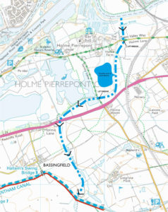
Click link for larger image trent-link-map-pdf
7.4 Water Supply
Long predicted to be a potential problem at the Trent end of the canal, so far as it is from the two main water sources of Denton and Knipton reservoirs, some thought has been given over the years to the means to address it.
As a result of investigations into a potential water supply it was proposed that an existing water supply main from the River Trent, which was previously used to supply water to Cotgrave Colliery washing plant, should be utilised in the first instance. This water main was originally used to deliver water at a rate of around 28l/s per minute. If water is to be pumped via the existing main, at a rate of 30 l/s per minute, the surplus will feed a 7,300 cu m storage lake/reservoir located to the west of the existing Grantham Canal, above Hollygate Lock (Lock 7) close to Cotgrave.
The condition of this water main is currently unknown and would require intrusive investigations at the detailed design stage. A new pumping station would also be required at the Trent end.
The supply of water could be provided by the existing main and the proposed storage lake would limit the number of boat movements along the canal link and restored canal to around 2,200 per annum. This assumes a boats-to-lock ratio of between 1.5 and 1.8 in the summer months. If that ratio is lower in practice, the number of boat movements that could be accommodated by this water supply would also be less.
In the event that there is greater demand for boat movements between the River Trent and Cotgrave and/or should the Grantham Canal become navigable beyond Cotgrave in the future, a greater supply of water would be required. It is recommended that consideration should be given to back-pumping around locks or installing a new water main to supply water from the River Trent. The new main could either be installed alongside a new multi-user route along the disused railway or at the foot of the railway embankment.
7.5 A52 Underbridge at the Polser Brook
The preferred canal link would pass under the A52 in the vicinity of the existing Polser Brook culvert. The two options are:
1. To use the existing culvert
2. To construct a new multi-use underbridge using the existing Polser Brook Culvert
The site of the Polser Brook culvert is not obvious when driving along the A52. It is situated close to the old school between Gamston Island and the right turn to Cotgrave. The culvert is in 3 sections. In the centre is the original A52 bridge and when the road was dualled the highways people built a new bridge either side.
There is sufficient air draught to get a narrowboat through this extended culvert but due to a kink in its line broad beam boats would not get through. There would be no room for a towpath through the culvert, preventing distance towpath walkers enjoying that facility.
The Polser itself would need dredging through the culvert to allow a one-metre water draught, which raises the issue of the depth of the foundations of the bridge sections as a whole and the original bridge section in particular. It is expected that at least the original bridge will need underpinning – a potentially expensive operation.
Building a Multi-User Underbridge, rather than use the existing culvert, which, due to its dimensions would prevent broad beam boat movement and would not allow a towpath to run through, it has been proposed that a new underbridge is constructed to take the canal link beneath the A52.
A new underbridge would be constructed so that it would accommodate a segregated multi-user route, capable of taking pedestrians, cyclists and horse-riders.
Removing the existing total barrier to multi-user movements presented by the A52 at this time would greatly enhance access and usability and fall in with the vision of the canal as the core of the Green Corridor proposal up to and past Cotgrave that was made a few years ago.
This option would also remove the need for physically using the Polser Brook watercourse, a result understandably desired by the environmental group in the Grantham Canal Society and Partnership. A new cut independent of the brook, from the existing line of the canal to the Trent, would probably simplify water flow issues, especially in high rainfall/ high waterflow periods.
An underbridge would be expensive as a project but canalising an existing water channel, extensive underpinning of the existing culvert and dredging of the Polser watercourse, although superficially attractive, would also not come cheap.
In the 2008 project the broad beam new bridge option came out cheapest; this is due to the (possibly) high estimate for underpinning the existing bridge in the 1995 BW estimate and the (possibly) low estimate for a new dual carriageway bridge in the 2005 estimate.
However, the difference is small when considered against the overall backdrop of uncertainty and risk. If the new underbridge is selected, then the question of the A52 crossing (narrow or broad) will become clearer.
We could develop it further by factors such as some kind of risk element, land acquisition costs, developer contributions, social costs (traffic delays etc), general amenity value, (how it fits with the overall GI plan), archaeology issues, ecology issues, landscape issues, etc. But I think that this should really be done as a separate exercise to make the comparison between (presumably) Option 3 and Option 1b 1d (1c) as the costs are really still too close to make an overriding clear winner.
Extensive feasibility study of these options will have to be conducted and funding for an up to date survey and report on The Trent Link has to be a priority. Although the long term favourite, the Polser route has to pass muster with other options and the support of Canal and River Trust, local landowners, Local Councils and the Inland Waterways Association are vital in this respect.
8. In Conclusion
Put simply, there has never been a comprehensive, integrated strategy for the restoration of the Grantham Canal, from the Trent to the old Grantham Basin. As the Trent Link is the fundamental keystone to restore connectivity to the national waterways network, so the boring through the A1 embankment up to the old terminal basin site has to be validated to ensure that Grantham as a town, benefits economically and environmentally from the councils support over the past decade.
To achieve all of this that comprehensive, integrated strategy has to be developed, become a regional development priority and communicated to all vested interests, funding sources, government agencies and others. We have to convince all that full restoration is a “when” not an “if”, and the “when” is sooner rather than later.
To requote and extend the comment from section 2 above;
It is to the credit of Richard Parry, Chief Executive of Canal and River Trust, that following discussions with the Grantham Canal Society executive team, in early 2016 a group was established to develop a comprehensive restoration strategy for the Grantham Canal. This group represents Canal and River Trust, six local authorities, Grantham Canal Society, Grantham Canal Partnership, Inland Waterways Association, and Environmental Groups.
The Trent Link will obviously feature strongly in this process and no surer sign of fully restored future for the canal will be seen than when the funding is in place and the first sod has been cut to reconnect the Grantham to the national waterways network.
Author: DLB
Upload: TJ