Trent Lock to Fosse Bridge
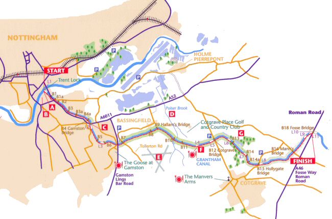
The canal began at the now restored lock [L1] by the Trent A, situated only yards from Lady Bay Bridge. The embankment here also forms part of the Trent Valley Way, which starts a few miles to the west of Nottingham and follows the river for 84 miles to West Stockwith. River currents often made entering this first lock quite tricky for barges getting into the canal and the bridge [B1] was, in addition to carrying the Trent towpath, a hauling bridge to assist them. Countryside asserts itself almost at once for 300 yards as rushes and overhanging trees crowd a narrow path alongside a now isolated section of water. Birdlife seems at home too in this city environment. These first few yards are the only part of the canal not owned by British Waterways, but by the Environment Agency.
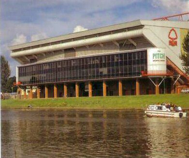
Notts Forest Football Club
As you pass the Nottingham Forest Football club stadium B you cannot fail to notice the Brian Clough stand named in memory of perhaps their most famous manager. The club was formed in 1865. Although this is their sixth ground, the club has been based here since 1899. Among their many achievements, Forest can also claim to have introduced shinpads to the game in 1874 and in 1878 they played in the first match at which a referee’s whistle was used.
The towpath now disappears under modern tarmac.
At the main road go right, cross left at the traffic lights, then cross right over Trent Boulevard to continue along Radcliffe Road. In a few yards a gap in the hedge on the left gives access to a narrow cinder towpath which has
a thick hedge and trees. In 200 yards there are the remains of floodgates. Rejoin Radcliffe Road briefly to cross Rutland Road beyond which a hand gate in the hedge near the bus stop regains the towpath. Following this is now a simple matter and in the company of coots, ducks and swans all nesting well into town, even in gardens, the first open fields on the far bank are soon reached as Gamston Bridge [E34] is approached. Only half the main road has to be crossed, the towpath continues under the bridge itself and so under the second “half” of the road.
Immediately beyond is the first winding hole [No.1], a broad pool where 75′ barges could be turned 13. A wide surfaced path now goes on to Bridgford Lock The walk out of Nottingham provides a revealing study in 20th century suburban architectural styles. Sweeping left the towpath reaches Gamston Lock L3 . and continues past another 20th century phenomenon, the out-of town superstore and the Goose at Gamston is seen close by. Cross the Gamston Lings Bar Road, going directly across (this text is a little dated – we do not recommend crossing this dangerous road as described, but to cross at the traffic lights 400yds to your left). A post, part of railings for steps leading back down to the towpath again, is visible on the far side. It is now 150 yards to Tollerton Road Bridge [B7] and the car park.
We enter genuine countryside at last with wide stretches of clear water, and trees which soon open out to reveal Bassingfield village on the opposite bank. Hallam’s Bridge B9 provides a footpath link to the village – but there is no pub! The Polser Brook aqueduct , is reached next.
On this stretch aerial activity betrays the presence of Nottingham Airport seen to the south E. Often referred to as Tollerton Aerodrome it opened as a city airfield in 1922 but became a training base for the RAF Reserve during WWII. It is now the home of the Trumanair Flying School and is a thriving private and commercial airfield.
A long straight, with the grounds of Cotgrave Place Golf and Country Club occupying the north bank, leads on to Skinner’s Lock [L4} E with the old lock keeper’s cottage and first canal feeder stream nearby. By the lock a plaque records the opening of a bi-centenary (1793-1993) canalside walk which gives the option of continuing to Cotgrave Bridge on either bank. There is a picnic area on the north bank too.
Beyond Cotgrave Bridge [B12] the canal is popular with fishermen. As we approach Cotgrave Country Park the canal has been much restored. The next two locks [L6 and L7] were both rebuilt in May 2000.
The park is on the site of Cotgrave Colliery which was planned as a show colliery for British Coal. It closed in 1993 due to unsuspected geological faults. Nottinghamshire County Council has been restoring the mine site to provide a wide range of facilities including walks and riding trails which link with the towpath. Some 2 million tonnes of soil have been moved and 120,000 trees planted. Access to the park can be gained just after the lock [L7]. Where the canal swings leftwards, a path through trees leaves the towpath for Cotgrave village. There is a pub, the Manvers Arms, and a fine church (All Saints) with 12th, 13th and 15th century stonework. The local rock (a fine grained Keuper marl) contains a blend of clay, calcium carbonate and silt which has found worldwide fame as a dressing for cricket pitches.
After Hollygate Bridge [B15] a wide stretch of water leads to Joss’s Lock [L8-unrestored] beyond which open water alternates with dense reed patches, whilst the wooded towpath affords only occasional glimpses of the surrounding countryside. Next comes Mann’s Bridge [B16] where the canal becomes more overgrown. The path narrows and as it rises up to two more unrestored locks [L9 and L10] the canal becomes quite dry. Pass under Fosse Bridge [B18] to a footbridge over the lock [L11] to the car park and picnic area.