Woolsthorpe Wharf to Grantham
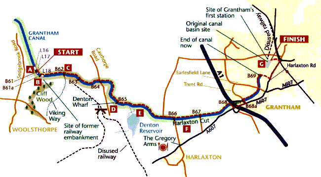
Beyond Woolsthorpe the towpath is again surfaced all the way to the A607 on the outskirts of Grantham. Within the environs of Grantham there is a mixture of grass and tarmac. This section does however contain two original 1790s bridges, both listed, together with perhaps the most significant, if not the most obvious, engineering feature in the form of the Harlaxton Cut. There is still plenty of birdlife, even in the town area, and because the waters are well stocked with tench, roach and rudd it is a popular section with anglers.
Go underneath Woolsthorpe Bridge [B61] with the 28-mile marker post below. On the opposite bank stands the old lock keeper’s cottage with Willis Lock [L17] looming over it. After the lock the towpath bends sharply to contour below Cliff Wood to Woolsthorpe Top Lock, [L18] the final lock on the canal, although there was still a 5-mile pound to go before the wharf in Grantham was reached
All three locks near Woolsthorpe Wharf, [L15] by the inn, as well as [L17] and [L18] on Section 6 have been fully restored to working order. Also the ironstone railway embankment, which once severed the canal between [L17] and [L18] has gone. There was originally a trestle bridge here when the line was built in 1883 but that was replaced by an embankment after the canal closed.
The old ironstone railway is such an obvious part of the scene at Woolsthorpe that its history deserves some comment here. The local ironstone was first exploited around 1879 when strata at Brewers Grave were worked. The ore was fed down through Cliff Wood on a 3-foot gauge tramway to Woolsthorpe Wharf. The 1883 `Belvoir’ branch line was initially intended to take over the transport of this ore supply but as more quarries were opened, first near Harston and later around Denton, Harlaxton and Stroxton, the lines were extended from 1916 onwards to finally total some 14 miles. Most of these are still fairly clear on the ground and are easily traced on OS. maps from Woolsthorpe to the vicinities of Harston and Wealdmore Lodge at Harlaxton. The lines finally closed in 1974.
At Longmoor Bridge [B62] the Viking Way departs uphill to the right on its journey southwards along Sewstern Lane to its final destination in Oakham. This is an ancient trading and droving route, most probably prehistoric in origin, from the Newark area to Stamford and thence to London. It seems likely that the construction of the canal obliterated part of its route. On the OS. map, compare the line of Sewstern Lane (for example around GR840376 and northwards) with the route going southwards from Brewers Grave.
From this point onwards there is a distinct sense of the hills closing in as from the north, the Lincoln Edge and the heathlands beyond it meet the Leicestershire uplands. Bridle Bridge [B63] is met next and its narrow wooden (almost Venetian style) arch has been specially designed to allow boating traffic. Next comes Casthorpe Bridge [B64], which although a modern, concrete affair has also been built to accommodate canal traffic.
Half a mile on is Denton Wharf with its parking facilities, picnic site and launching slipway which has won the GCRS award for its restoration work. Denton Bridge [B65] has its name painted underneath and, as one of the original bridges from the canal’s construction in the 1790s, is listed as being of special architectural interest. In a further 1/4 of a mile the Denton Feeder can be seen on the south bank, though the reservoir from which it flows (so obvious on the map) remains out of sight behind woodland.
The Denton Reservoir was also constructed specifically to supply the canal and it is fed from springs in Denton Park and other streams coming off the hills near Harlaxton. Its capacity is 61 million gallons. Today it provides a fine circular walk, is a haven for many species of wildfowl and is a popular fishing location. However it can only be approached along footpaths to the south of the canal and not from the towpath.
There is another winding hole nearby and then the towpath crosses a sluice draining off excess water. The valley now becomes much narrower (study the OS. map contours) and the 65 metre (200 feet) contour is crossed as we enter the Harlaxton Cut. This has an average depth of 20 feet, stretches for almost a mile towards the A1 and was perhaps the most substantial civil engineering work of the whole canal. Half way along is Harlaxton Bridge [B66] and wharf. At the roadside near the bridge are signs detailing facilities in Barrowby and Harlaxton e.g. shops, pubs, churches – all measured in yards! [now sadly gone thanks to a wayward car]. The Gregory Arms at Harlaxton is about a quarter mile detour south along the grassy verges of The Drift, another old drove road. Barrowby is uphill and well over a mile away. Harlaxton Wharf [now restored] is sited beyond the bridge on the far bank.
Just before Vincent’s Bridge [B67], and 2 miles from Grantham, a seat offers the chance of a short rest. Vincent’s Bridge is another original from 1793 and it too is listed. Once beyond it there are soon glimpses through the trees of vehicles on the A1.
Between Harlaxton Bridge and the A1, the embankments of the cutting are covered in wild flowers, and especially in spring and early summer there are drifts of red and white campion together with pink hybrids. Immediately below the A1 embankment, turn right over a footbridge crossing the canal culvert and walk via a leafy tunnel through trees to the A607 road. The Restoration Society has long term plans to create a new Grantham basin here.
We now enter the urban area surrounding Grantham and it will be safest to use pavements wherever they are available. Turn left along the A607 to pass under the A1. After a quarter of a mile turn left again onto the slip road signed for the A1 (South) but bear right over the barrier near the roundabout next to the Urban Hotel to rejoin the canal towpath. Follow Redmile Walk to cross Trent Road and, with increasing urbanisation, reach Earlesfield Lane [B69]. Before all the surrounding estates were built this was formerly known as both Hollis’ Bridge, as it was in Hollis’ Lane, and locally as `Skinyard Bridge’ on account of a tannery nearby.
The canal effectively finishes here. The water certainly does! Intrepid souls may press on past a few houses and then through undergrowth to the security fence of a large scrapyard which now occupies the filled in canal basin. There is no possibility of further progress however and a return must be made to the bridge at Earlesfield Lane.
The only course now is to turn downhill before going left along Harlaxton Road towards the town centre. Old Wharf Road, which led to the canal basin, lies on the left immediately after the railway arch.
The Grantham Canal basin was sited at GR908356. G The general layout is still discernible on the OS map, as is the route taken in 1850 by Grantham’s first railway (the `Ambergate’) to its station on the same site. Here for a while was a scene of great activity as Grantham prospered following the canal opening. Trade flourished both into and out of the town, and industry within the borough developed. A measure of this is shown in records of almost 12,000 quarters of grain passing though the canal granaries in two years from 1802. As canal trade declined, local entrepreneurs took over and it was possible to hire rowing boats at the wharf. Like Hickling Basin it too became a venue for social events and in 1906 the Skegness lifeboat was launched there for publicity and fundraising purposes.
Following the closure of the canal in 1929 the granaries were soon demolished, many going that same year. Eventually the basin was filled in and the majority of the site is now occupied by Lee’s scrapyard.
A short detour to the left along Old Wharf Road can be made by anyone determined to get as close as possible to where the canal ended, but there is nothing of the canal itself to be seen, even if there were access to the scrapyard.
The end of the walk is therefore unavoidably accompanied by a twinge of sadness, and thoughts of the asset that the old canal basin and its buildings might now have been to Grantham had they survived. However, in the Grantham Local Plan no building projects will be allowed on this land – in case at some future date the basin could be rebuilt. Beyond the railway, Westgate leads directly into Grantham town centre.
Harlaxton Manor was built in the 1830s for Gregory Gregory, a wealthy Nottinghamshire businessman. Having travelled throughout England and Europe seeking inspiration, ideas and indeed artifacts for this huge house, Gregory employed Anthony Salvin as architect and Harlaxton Manor must be regarded as Salvin’s masterpiece. Owner and architect had many differences of opinion, however, and Salvin having completed the exterior of the main building was replaced by William Burn who is thought to be responsible for much of the interior.
Harlaxton Manor is a private residence and is only open to the public two days a year in June and July. Group guided tours can be arranged at any time by appointment. The Manor is located on the A607 in Harlaxton, 3 miles west of Grantham, 1 mile from the Canal. For further details telephone 01476 403000.