Harby (Langar Bridge) to Redmile
The village of Harby lies on a ledge below the steep Belvoir escarpment to the south, but is sufficiently elevated to give wide views northwards over the Vale.
Quite apart from frequenting the inn, there is much else to see in the village, A Harby was spelt with a `d’, that is `Hardebi’, in the Domesday Book and the village is believed to be the birthplace of Geoffrey Hardebi a privy councillor and confessor to Edward III. The green has the remains of an ancient village cross, locally known as the `Butter Cross’. This originally stood near the church but stands now by the school, restored as part of the WWI memorial and with a record of village life sealed within it.
A pathway nearby leads to St. Mary’s churchyard built in 1485 (actually rebuilt from an even earlier one). Many of the windows have exceptionally well preserved label stops, the architectural term for carvings where the arch meets the uprights. Inside, more fine carvings adorn the corbels supporting the roof beams. The figure to the northeast being particularly noticeable as a `girner’, fingers in mouth, in an attempt (successful one might add) to create a grotesque face at onlookers below. A written guide tells of many other interesting features.
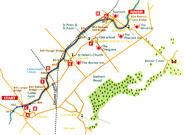
 If you do not mind missing a few yards of the towpath at the beginning of this section, a footpath leads from a gate near the northwest corner of the churchyard, joining the canal at [B44] opposite Glebe Farm. Otherwise, start this section from Langar Lane [B43]. The character of the walk now changes considerably, for beyond Harby the towpath surface is grass as far as Redmile Mill Bridge [B53] from where a short final stretch is surfaced to Redmile Town Bridge [B54] and the village itself. At several points, medieval ridges and furrow fields on the slopes either side of the canal are evidence of the antiquity of the landscape.
At the bridge [B44] where a footpath crosses the canal towpath, there is a small bench seat on the opposite bank for anyone needing an early rest. This is also a good spot to look down towards Glebe Farm. The `Glebe’ name tells us that the origins of the farm go back hundreds of years; `Glebe’ lands were those allotted to the local clergyman who farmed them and retained all the income. This bridge is also the start of a Site of Special Scientific Interest (SSSI), which includes the towpath for some four miles to Redmile Mill Bridge. As a consequence this section of the towpath is unlikely ever to be fully surfaced. The site is of importance for an exceptional range of aquatic and marginal plants, all of which are adapted for slow moving water.
After [B44] the towpath is lined with abundant horsetails, members of the Equisetaceae family of nonflowering plants, and one of our most ancient plant species. Just before Stathern Bridge [B45] is another winding place for turning canal barges and by it, on the opposite bank, is a picnic site.
The towpath leads on past extensive reed beds where reed buntings may sometimes be spotted. The first of two railway bridges is met at[B46A] which carried the LNWR and GNR joint railways over the canal. This branch heads northwest towards Bingham and Nottingham. Underneath, a painted sign proclaims “1879 – Melton to Bingham Line”. The line to Newark is met soon afterwards at [B47A] which has been removed. Their junction lies just south of the canal. The `A’ appendix to the bridge numbers was of course necessary to identify these `extra’ bridges built almost 100 years after the canal. The unused trackbed, embankments and cuttings are now important wildlife habitats. There are more ridge and furrow fields on the south bank.
From [B49] it is a very short detour into Plungar village E, the `Point of land where plum trees grow’, and another ancient inn, The Anchor. It was originally intended to build an inn beside the canal but somehow it ended up in the village as a conversion from cottages which once also served as the local courtroom.
 St. Helen’s Church in Plungar should not be missed. An Anglo-Saxon church stood nearby in what is now the garden of Manor House Farm and a holy well was situated near the steps which still lead down to the lawn. The present church site has been used from around 1240 and some old stonework remains, but the unbuttressed tower dates from 1846 and other restoration work took place from 1855. To quote the church guide, St. Helen’s is `rich in animal symbolism’; there are medieval animal heads on the choir stalls supplemented by additional Victorian ones. The most unusual figures, however, are 15th century and on the outside west wall of the tower. They illustrate `The Tale of Reynard the Fox’, popular in medieval times and widely believed to have originated in France. The church guide itself is informative and (this is unusual) written with a definite sense of humour. Funny now, though perhaps not when it happened, is the tale of the eccentric village grocer, also a churchwarden, who in the early 1700s tore out pages of the parish registers to wrap up tea and snuff.
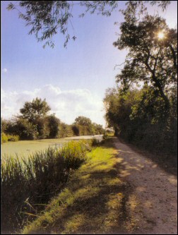
For a couple of miles now the railway and towpath keep close company. At [B50] an original 1879 railway bridge can be seen to the left whilst to the right the spire of Barkestone church peeps over the low hills. The track from [B50] affords an opportunity to visit the small village of Barkestone-le-Vale; the village has an inn, though it only opens intermittently, but no shop F. Apart from the church, the most imposing building stands on the corner of The Green. This is the Old School, established in 1814, which carries a fine clock tower; it is now the village hall. There is also a converted windmill. St. Peter and St Paul’s church has 15th century carving inside dating from the time it was built, including a fine screen and a wooden beam, plus Norman carving on the south door. By the south porch stands a huge yew tree mentioned by Arthur Mee when writing his King’s England series of books some 60 years ago. He said the circumference was 12 feet then; so it looks even bigger now! A lane by the church leads back to the canal [B51] with only a quarter of a mile or so of towpath being omitted.
 At the point where the railway departs to the left was the site of a rather special station G. It was constructed in 1878 for a visit by the Prince of Wales and to serve Belvoir Castle, and as such was the scene of many subsequent royal arrivals and departures. There were ornate turrets and garlands over the entrance but sadly the station was demolished in 1951. The line itself closed in 1962.
Near this point too is a pipe bridge H. This replaced something even more unusual however. When the canal was built, the original bridge here [B52] was a swing bridge known as Redmile Wooden Bridge, which enabled the local farmer to get to his fields on either side. During WWII however this was left `open’ and a new bridge built to access a petrol store on the south bank. This was on rails, rather like an enormous gangplank, which could be withdrawn to the far bank, so allowing barges to pass. Both were still there for many years, at least until the 1970s, but have now gone.
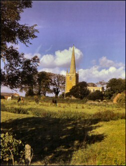
At Redmile Lane and Redmile Mill Bridge [B53] the SSSI ends and a notice invites you to visit the Peacock Farm Tearoom which is only 100 yards away down the hill at the road junction. The towpath is now surfaced as far as Redmile Town Bridge with an ancient ridge and furrow landscape either side, clearly seen where the canal crosses a shallow valley on an embankment, from which Redmile village also comes into view with Belvoir Castle crowning the hillside behind. Visible to the northeast whilst approaching Redmile is Bottesford church, the `Lady of the Vale’. Redmile Town Bridge [B54] retains half an original metal bridge number plate. You will need to go under the bridge and double back up the road to reach the village.